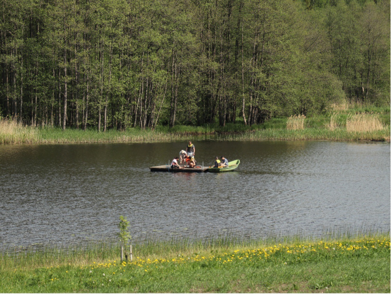
Exploration of the lake within the framework of the Quaternary Geology Course.
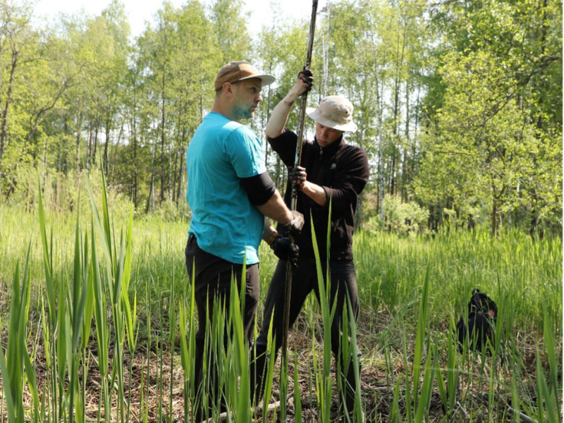
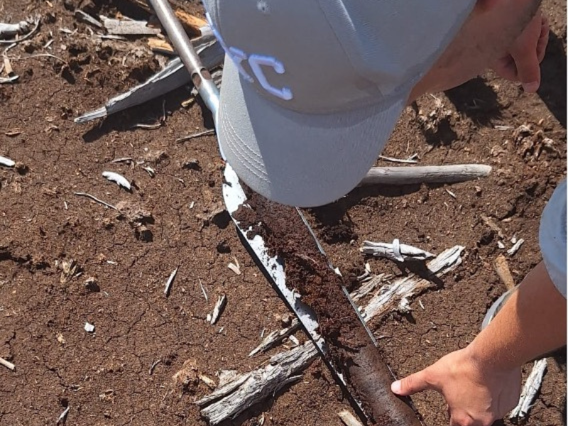
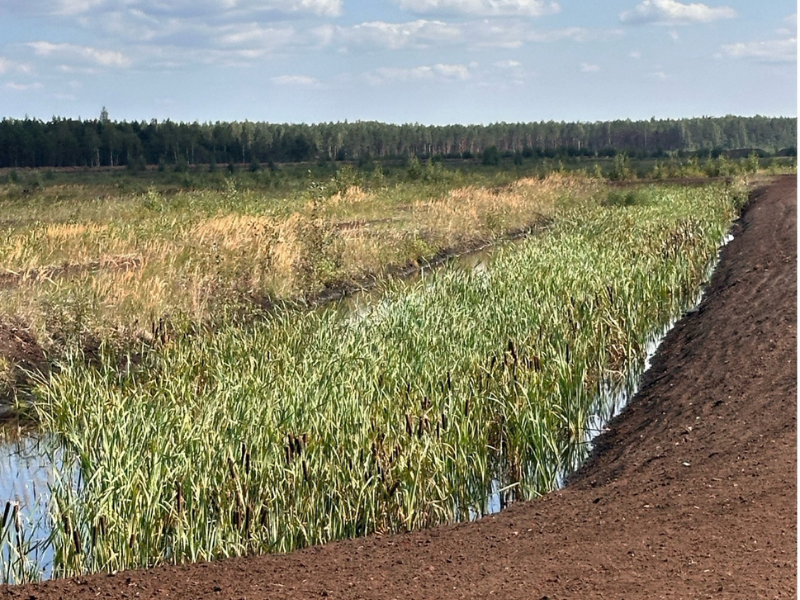
Obtaining swamp sediments for further analysis in the laboratory.
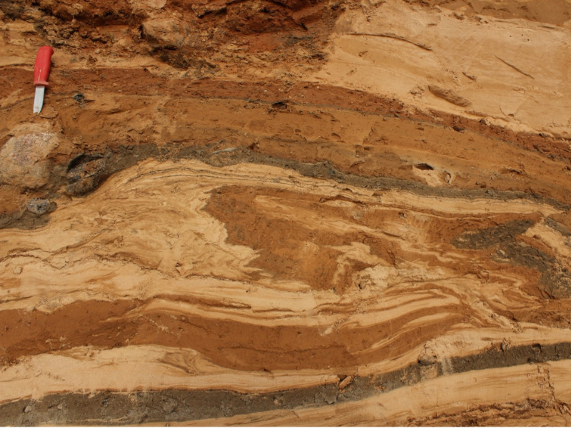
Glacier plastic deformed moraine sediments in quarry Mashen near Baldone
Research
The Centre for Quaternary Geology, Geomorphology and Polar Research (GGPPC) conducts fundamental and applied research on the development of the Earth's surface over the last 2.58 million years in Latvia and the polar regions (including Antarctica, Greenland, Svalbard and Iceland). Particular attention is paid to the study and mapping of sand, gravel, peat and lake sediments, as well as the analysis of long-term landscape and climate change.
The KGPPC also develops methodologically innovative directions using smart tools and machine learning technologies to perform mapping of terrain forms and reconstruct the stages of glacier retreat in the territory of Latvia. Studies are being carried out on changes in the level of the Baltic Sea, the development of lakes and peatlands, as well as the interaction of vegetation and man with the environment (including historical anthropogenic pollution) over the last 15,000 years.
Main research directions:
- The origin and development of Quaternary sediments and relief forms in Latvia and the polar regions
- Reconstructions of glaciation and deglaciation
- The study of karst and other modern geological processes
- The development of lakes and peatland and landscape changes in the Holocene and its driving factors (geomorphology, climate, fires, storms, episodes of pathogens and plagues)
- Reconstruction of anthropogenic impact on the environment (ecological changes in forest composition and lakes)
- Recultivation of peatlands, introduction of paludiculture and monitoring of CO2 emissions
- Studies of modern glaciers
The main research methods
- Geological coring and sampling in organic and clastic sediments
- Geological and geomorphological mapping
- Photogrammetry, creation of digital terrain models and their derivatives (from data from unmanned aircraft cameras and LIDAR data) and analysis
- Geospatial analyses in the GIS environment
- Determination of the sedimentary conditions, textures and structures of clastic sediments and measurement of directional elements in outcrops
- Clastic sediment (sand, gravel) analyses
- Analysis of the composition of organogenic sediments (peat, gyttja [sin.sapropel])
- Pollen analyses (from lake, peatland and soil sediments and archaeological sediments/samples)
- Non-pollen palynomorphs – algae (from lake sediment)
- Non-pollen palynomorphs - phytoliths (from lake sediments, soil and archaeological sites)
- Macroscopic charcoal morphology analysis
- Sediment loss on ignition (relative composition of sediment)
- Sediment dating (last ~70 years) using spheroidal carbonaceous particles
- Use of Eddie covariance towers to measure CO2 flows
Partners
The KGPPC actively cooperates with Latvian and foreign scientific institutions, municipalities, companies and industry experts. Expertise services and performance of contract work are provided (e.g. peatland inventory; development, monitoring and monitoring of peatland recultivation plans; carrying out analysis and monitoring necessary for carbon certification (peatlands); impact of solar and wind farms on wetlands; study of lake sediments and preparation of science-based management recommendations for lake conservation, creation of very high resolution terrain models and orthophoto for various purposes, etc.). Researchers regularly participate in public education in television broadcasts (LTV1), radio (LR1) and popular science publications in magazines, newspapers and Internet portals. Articles in the National Encyclopedia are regularly updated: enciklopedija.lv
The leading researchers of the GGPPC (Normunds Stivriņš and Kristaps Lamsters) participate in and lead both national and international scientific projects (for example, Horizon2020, INTERACT, projects of the Latvian Council of Science) and ensure the involvement of students in research in the fields of geology, geography, biology, environmental science and history.
Most significant publications
Climate change impact on peatland dynamics during the Holocene in Latvia, Northeastern Europe. Catena, 254, 108965. doi.org/10.1016/j.catena.2025.108965
Downward migrating microplastics in lake sediments are a tricky indicator for the onset of the Anthropocene. Science Advances, 10: eadi8136. https://www.science.org/doi/10.1126/sciadv.adi8136
Palaeoecological data indicates land-use changes across Europe linked to spatial heterogeneity in mortality during the Black Death pandemic. Nature Ecology & Evolution, 6, 297-306.
Geometry and thermal regime of the southern outlet glaciers of Qaanaaq Ice Cap, NW Greenland. Earth Surface Processes and Landforms, 49(13), 4275-4288. https://doi.org/10.1002/esp.5966
Drainage system and thermal structure of a High Arctic polythermal glacier: Waldemarbreen, western Svalbard. Journal of Glaciology, 68 (269), 591–604, https://doi.org/10.1017/jog.2021.125
Liquefaction and re-liquefaction of sediments induced by uneven loading and glacigenic earthquakes: Implications of results from the Latvian Baltic Sea coast. Sedimentary Geology, 421, 105944. https://doi.org/10.1016/j.sedgeo.2021.105944
High-resolution orthophoto map and digital surface models of the largest Argentine Islands (the Antarctic) from unmanned aerial vehicle photogrammetry. Journal of Maps, 16(2), 335–347. https://doi.org/10.1080/17445647.2020.1748130
The full list of publications is available at:
Normunds Stivriņš: Scopus ID: 55180665800 (https://www.scopus.com/authid/detail.uri?authorId=55180665800 )
Kristaps Lamsters: Scopus ID: 55339485000 (https://www.scopus.com/authid/detail.uri?authorId=55339485000)
Current projects
European Research Council, HORIZON 2020, ERC-2024-SyG grant consortium project EUROpest (101166700) “A Novel Understanding of Pandemic Disease in Preindustrial Europe (1300 – 1800): Combining History, Machine Learning and Natural Sciences”, University of Latvia (2024-2030; N. Stivrins, participant).
COST Action CA23116, Open Palaeoecological Data - analysing the past building foresight (PalaeOpen). Working group: Data communities – Terrestrial and Data Communities – Aquatic member. 2024.-2028. (N.Stivrins, MC Member)
Latvian Council of Science project lzp-2021/1-0163 "Burial traditions in the landscape: the territory of Latvia in the Iron Age (1st – 1200th)", main performer (N. Stivriņš), 01.08.2022.-31.07.2025.
Latvian Council of Science project "Reconstruction of ice flow dynamics and deglaciation course of the Scandinavian ice shield DA sector in Latvia" (lzp-2024/1-0193) (2025-2027; main performers K. Lamsters, N. Stivriņš)
Head of the Unit
Prof. Normunds Stivriņš
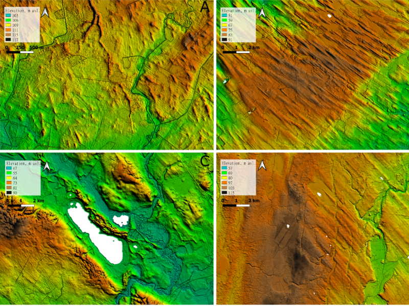
Examples of glacier relief forms in a digital terrain model. A: crack fill ridges in A-Latvia, B: Burtnieks drumlin field, C: ridge-shaped oss in the tunnel in Z-Latvia, D: landscape of pulsating ice lobes and tongues with crack fill ridges (left) and oversized glacial lineaments in Kurzeme.
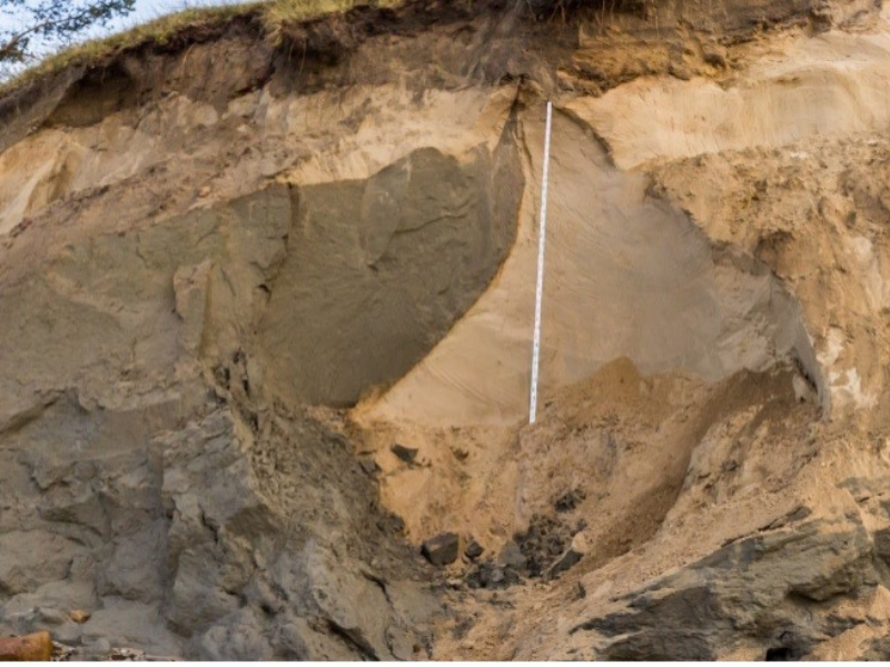
Clay silt diapyr (passive deformation structure) on the bluff of the Baltic Sea near Ulmale
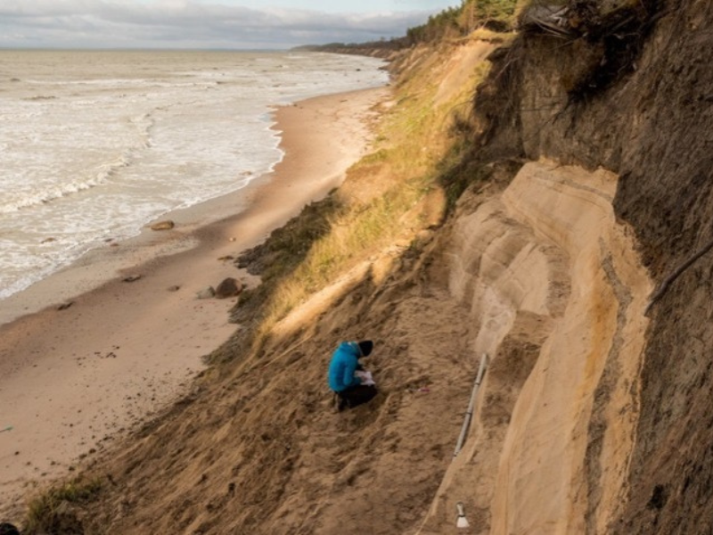
Studies of soft sediment deformation structures in the outcrop on the bluff of the Baltic Sea near Baltmuiža.
During the inventory of the swamp, peat was analyzed and described.
Hawthorn grove as a paludiculture in the territory of the peat bog (SIA "Laflora") developed.
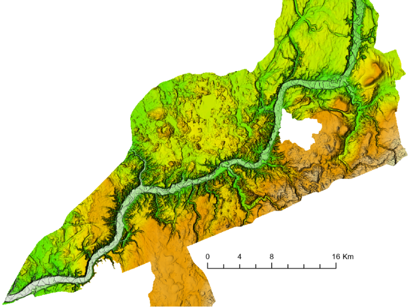
A terrain model with a shading effect in the vicinity of the Gauja valley is formed from LiDAR data.